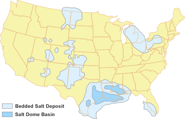
Deposits of rock salt thick enough for underground mining or solution mining form under a rare set of geological conditions. The deposits shown on the accompanying map formed during times of high sea level, when shallow seas spread over extensive areas of continental crust. To deposit a thick layer of salt, long periods of sea water evaporation had to occur in an arid climate, in basins where there was a continuous or repeated influx of new ocean water.
Over 100 feet of ocean water must be evaporated to produce a single foot of salt. So, to produce a salt layer that is 50 feet thick, over one mile of sea water would have been evaporated. The water was not a mile deep. Instead, there was a continuous – or a repeated – inflow of salt water from the ocean into the salt-forming basin – which was in an arid area and subsiding at a rate that allowed the accumulation of a thick salt.
The formation of thick salt deposits in these basins was a marvel of nature.